
We present 11 years of such data for a relict permafrost site at Mahan Mountain on the northeast of Qinghai-Tibet Plateau. The meteorological data are comprised of air temperature, air relative humidity, wind speed and direction, shortwave and longwave downwards and upwards radiation, atmospheric pressure, precipitation, and ground surface temperature on half-an-hour timescale. The active layer data include daily time series of soil temperature and soil moisture at five levels. The permafrost data consist of ground temperature at twenty depths. The released high-quality and long-term datasets are expected to serve as accurate forcing data and validate and assess remote-sensing products and land surface models for a broader geoscientific community.
2021-11-29
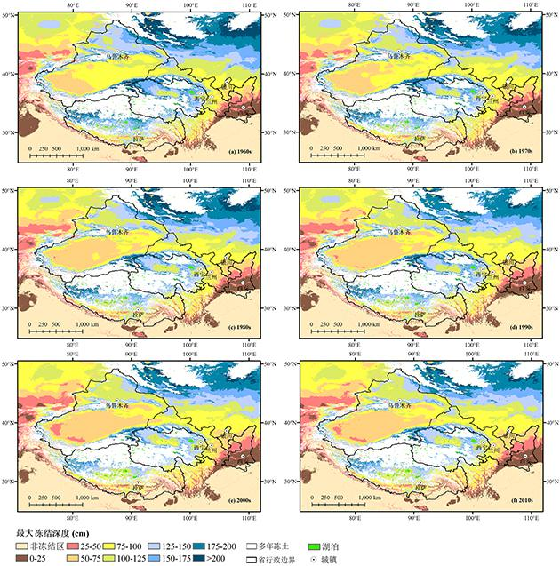
最大冻结深度是季节冻土热状态的重要指标,由于全球变暖,季节冻土的最大冻结深度不断下降。发布了中国西北五省、西藏和周边地区1961-2020年每10年的最大冻结深度数据集,空间分辨率为1km。该数据集是采用2001-2010年的最大冻结深度实测数据和空间环境变量构建的支持向量机回归模型,模拟了1961-2020年中国西北、西藏和周边地区的最大冻结深度。验证结果表明:支持向量机回归模型具有良好的空间泛化能力,最大土壤冻结深度的预测值和实测值之间具有较高的一致性,1980s、1990s、2000s和2010s四个时期模拟结果的决定系数分别为0.77、0.83、0.73和0.71。预测结果的百分位区间表明,模拟结果具有良好的稳定性。基于该数据集,发现我国西北地区最大土壤冻结深度不断下降,其中,青海的下降速率最快,平均每十年下降0.53 cm。该数据集为中国西北、高山亚洲和第三极等地区季节冻土的研究提供数据支持。
2021-10-27
联系方式
 中国科学院西北生态环境资源研究院
 0931-4967287
 poles@itpcas.ac.cn
关注我们

时空三极环境大数据平台 © 2018-2026
陇ICP备19003365号-4 | All Rights Reserved
|  京公网安备11010502040845号